How Can Lawyers Use Google Maps?
Google Maps is especially useful for getting directions and traffic updates and finding local businesses such as restaurants and more in proximity to a certain location. It can even provide voice guidance to help walk around an unfamiliar city. But, really, that is the tip of the iceberg. Google Maps could help you look at a location without having to physically visit and “drive” to see the surrounding area, which can be useful for case investigation and understanding the scene of an accident or crime.
Google Maps in the Browser
A basic search for an address or business will take you to a road map on the screen. You can zoom in or out by using the plus or minus signs at the bottom right. You can get directions, save it in your favorites, send to your phone and search for businesses nearby. For more options click on the hamburger (three stacked horizontal lines) menu at the top left of the navigation panel. You will see many options including:
Satellite
The Satellite view in maps is a bird’s eye perspective of the map that will show detail like vegetation, parking lots and other details not seen in the road map view.
Traffic
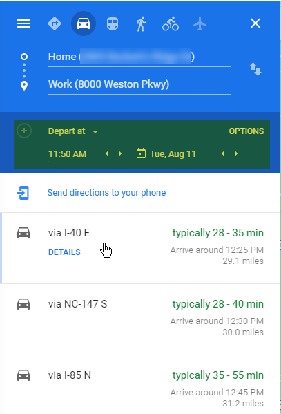 In either map view or satellite view you can click on Traffic to see either live traffic (default) or choose “Typical Traffic” from the small drop-down menu in the Traffic box on the screen at the bottom. You can then choose the day of the week and the time of day to see statistically “typical” traffic in an area. This information could be useful if you are driving, or if you are trying to determine the amount of time it takes to drive from one place to another based on usual traffic. Click on “directions” and map a point-to-point drive and find out how long it takes based on a specific departure or arrival time by clicking “Leave Now” and choose “depart at” or “arrive by” in the options. You can choose a date and time in the past, as well as the future.
Street View
Want to “walk” around an address without visiting the site? Click on Street View and then click on the address (the red pin) and Google Maps will zoom in onto street level and you can use your mouse to “walk” around an area. This is handy if you are visiting a new courthouse and want to get the lay of the land or going to a new client site and need to see street parking options.
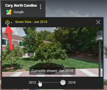
Does the scene look sunny and warm even though it is the dead of winter? In the upper left corner of the screen a box shows the address you are viewing and the date the image was captured. There may be a clock icon indicating there are more images. Click the clock icon and you can see images of the same street taken by year and month on a timeline. For instance, zoom in with the plus sign in the bottom right to discover a Tow Away zone sign that wasn’t there a few months previous. You can also drag the “Peg Man” (the yellow stick figure in the bottom right of the screen) onto a pinned address or anywhere on the map to zoom to the street view.
In Road Maps view click on a business or public building and in the left column there may be photos or videos available submitted by Google users, including 360 photos so you can “walk” around inside. The date and the name of the person who submitted the image is displayed.
Google Maps for Investigation and Evidence
Since you can go to a street view captured at specific times, usually a few years apart, you may be able to view a location for road conditions, whether the exit to a building was blocked, or other information that is vital to your case without leaving your desk. You may be able to establish drive times with typical traffic on a date to validate – or disprove – a timeline or alibi. Coupled with Weather Underground Historical Weather information you may be able to establish a fact set that corroborates testimony. You can use this information at the beginning of a case to begin your research, but can you rely upon it as evidence to the court? One litigation support company explains how to use Google Earth images for work up on a case. This illustrative article from a personal injury firm shows how they use Google Maps to help with an injury case. They point out some of the limitations and considerations for using Google Maps, including that the information is helpful in investigation, but cannot be used on its own to win a case. However, New York recently amended §4511 of the Civil Law and Practice Rules (“C.P.L.R.”) to require courts to take “judicial notice” of digital mapping images and related information. Courts can take judicial notice of a fact when it is a well-known or indisputable, proven fact. Of course, the rules of evidence will still apply and a 2019 appellate court in Florida rejected the use of images mined from Google Maps due to a lack of authentication. Depending on how you want to use the information mined from Google Maps (which include Street View and Google Earth) you may be able to bring it as evidence. Before you rely on images from Google Maps check the rules and the court and do your research!
Navigation with the Google Maps App
While your travel may have been curtailed due to the pandemic, we will be back on the road soon and there are a few things to know about the power of Google Maps for getting around.
Google Maps Driving Mode for Android
A recent update to the Google Maps app in Android replaces Android Auto to enable driving mode, which limits your ability to do anything on your phone when driving directions are enabled. Your phone will go into hands free mode and the Google Assistant will read text, make hands free calls, and play music. No word on the equivalent for iPhones, although there are plenty of tips to leverage Google Maps driving directions on your iOS device.
Real Time Driving Hazards
If you typically use Waze as your driving app of choice because of the real time user input, now Google Maps has that feature too (though law enforcement isn’t thrilled that drivers are getting notified of upcoming speed traps). You will get voice notifications as you drive about construction, lane closures, disabled vehicles, and objects in the road. This information can be hugely useful if you find your drive slowed to a crawl due to highway construction. Even if you have driven a route a thousand times turning on the app can help you get to your destination with minimal hassles.
Alternate Transportation
Prefer walking, biking, ride share or public transportation to driving? Even if you drive locally, if you are visiting a city you might not need to rent a car and save some money if there are alternate modes of transportation. The Google Maps app will let you choose between a variety of modes of travel so you can see which are best when getting around at your destination. A ride share service may seem expensive if you already have a car, but factor in the cost of parking (and parking hassles) and that may make the best sense. Or you may be two stops away from your destination if you take public transportation. You can check time estimates for bikes, walking, ride share and public transportation in many areas.
Augmented Reality Walking Directions
A recent upgrade to walking directions for major US cities can give you a virtual reality experience while walking in an unfamiliar area. You can turn on Live View and your Google Map walking directions will be superimposed on the area ahead of you by using your phone’s camera. It is worth trying out for the novelty but walking down a busy city sidewalk staring at your phone invites all sorts of trouble. However, if you have some earbuds you can use them to get narrated directions so you can put your phone in your pocket and Google will tell you when to turn left or right – discreetly.
Offline Maps
If you are driving in an area and know you will depend on broadband access for your maps app to work, you may want to download a map to use offline. You can download a map if you are exploring a new town or an area so you don’t lose your way, even if you lose 4G. You can be prepared for the dreaded “GPS signal is lost” alert.
Find Parking (and Where You Parked)
In addition to Google Maps helping identify public and paid parking with a P symbol on the map, now you can remember where you parked without having to take a picture (or multiple pictures). Once you have parked tap the blue location dot in iOS or Android and select “Set as Parking Location” in the options. A “P” icon will appear alongside a note that says, “You Parked Here”. In Android you can also add details like meter reminders, or the parking garage level.
Google Maps and Privacy
Google doesn’t have the best track record with privacy and as delighted as you might be with the ability to leverage Google Maps street view, you may be mortified that anyone can look at your house or your client’s house just by typing in an address. If you have GPS on by default and use Google Maps app your activity is tracked and stored in your history.
Blur Your House
If you don’t want to have people see your house or building, or if you think that you need to tell a client to protect their privacy due to fear of violence, you can request that Google blur the picture in Street View. They will warn you this is a permanent action (OK!). Go to Google Maps and put in the address. Go to Street View and click “Report a Problem” in the bottom right corner of the browser screen. Center the red box on your home and select “My Home” in the “Request Blurring” field. Provide a reason, like “safety issues”. Then click submit. You may want to do this on Bing Maps too.
Turn Off Location Tracking
Google tracks your location for “convenience”. Go to https://myaccount.google.com, log in to your Google account and in the Data & Personalization toggle off location history to pause the collection of your location data. You can also set auto-deletion of your location and see and delete your history.
Google Maps Timeline
Even with location tracking paused, Google Maps may still track your activity through Timeline. Open the Google Maps app on your phone, tap your profile picture and go to Your Timeline. Tap the vertical ellipses to get to Settings and then scroll to the Locations settings. You can delete everything in your history by tapping on Delete All Location History.
Conclusion
Google Maps is a suite of sophisticated tools with all sorts of uses and implications. It is a treasure trove of data that can be used for good or for ill. You may find it extremely useful in your practice and personal life but be aware of unintended consequences. There is far more to discover about Google Maps and its uses, so get ready to start your journey.